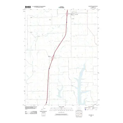
2010 Map of Van Wert
USGS Topo · Published 2010About this map
Van Wert serves as the primary hub in this portion of Decatur County, where the local community is anchored by the Van Wert Post Office and the nearby Van Wert Cemetery. The landscape is defined by the drainage patterns of the West Little River and Redmans Branch, which carve through the agricultural terrain. For those researching local lineages, the map identifies several smaller, family-named burial sites scattered across the township, including McKee Cemetery, Clinton Cemetery, and Shy Cemetery. These sites are linked by a network of secondary roads such as Co RD j14 and Co RD r40. The small settlements of Kingston and De-Kalb appear along these routes, illustrating the dispersed residential pattern of rural Iowa at the start of the 21st century. The map also traces the winding paths of Long Creek and Short Creek as they navigate the fields south of the primary town center.
Find a feature on this map
33 named features on this map. Tap any name to fly to it.
Don’t see what you’re looking for? This feature index may not catch every label — zoom into the map to look around manually.
Map Details
Editions of this 2010 Van Wert Map
This is the sole edition of this map. No revisions or reprints were ever made.
Other maps of this area

1945 · Lamoni
USGS Topo · 1:62,500

1947 · Lamoni
USGS Topo · 1:62,500

1954 · Centerville
USGS Topo · 1:250,000

1957 · Centerville
USGS Topo · 1:250,000

1958 · Centerville
USGS Topo · 1:250,000

1964 · Leon
USGS Topo · 1:24,000

1965 · Weldon
USGS Topo · 1:24,000

1965 · Garden Grove SW
USGS Topo · 1:24,000
1981 · Van Wert
USGS Topo · 1:24,000
1981 · Hopeville
USGS Topo · 1:24,000