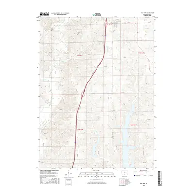
2015 Map of Van Wert
USGS Topo · Published 2015About this map
Van Wert occupies the northern portion of this Decatur County landscape, serving as a primary point of settlement along the regional road network including Line St and 5th St. The terrain is defined by a dense network of drainage, where the W Little River and its tributaries like Redmans Br and Long Cr carve through the agricultural fields. For genealogists, the map is particularly useful for locating several rural burial grounds that dot the townships, including McKee Cem, Clinton Cem, and Shy Cem. The spatial distribution of these cemeteries, such as the West Cem and Van Wert Cem, highlights the historical community clusters that formed around these watercourses and early section lines in the early twenty-first century. This survey documents the intersection of modern transit and traditional land divisions at the boundary of T70N and T69N.
Find a feature on this map
39 named features on this map. Tap any name to fly to it.
Don’t see what you’re looking for? This feature index may not catch every label — zoom into the map to look around manually.
Map Details
Editions of this 2015 Van Wert Map
This is the sole edition of this map. No revisions or reprints were ever made.
Other maps of this area

1945 · Lamoni
USGS Topo · 1:62,500

1947 · Lamoni
USGS Topo · 1:62,500

1954 · Centerville
USGS Topo · 1:250,000

1957 · Centerville
USGS Topo · 1:250,000

1958 · Centerville
USGS Topo · 1:250,000

1964 · Leon
USGS Topo · 1:24,000

1965 · Weldon
USGS Topo · 1:24,000

1965 · Garden Grove SW
USGS Topo · 1:24,000
1981 · Van Wert
USGS Topo · 1:24,000
1981 · Hopeville
USGS Topo · 1:24,000