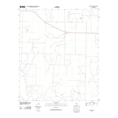
2010 Map of Vancourt
USGS Topo · Published 2010About this map
Vancourt anchors this Tom Green County landscape, situated where the high-speed transit of Highway 87 intersects a network of local roads that serve the surrounding agricultural and petroleum lands. The terrain is characterized by the expansive Lipan Flat, a level region carved by the wandering paths of Lipan Creek and Hog Marsh Creek. The map reveals the local industrial footprint of the early 21st century, specifically through the Yan-Kee Canyon Oil Field to the northeast and the Rusti Oil Field in the south. A dense grid of named roads, including Streicher Rd, Fort McKavett Rd, and Susan Peak Rd, suggests a well-distributed ranching or farming community, where property access and mineral extraction define the local economy and land use patterns.
Find a feature on this map
25 named features on this map. Tap any name to fly to it.
Don’t see what you’re looking for? This feature index may not catch every label — zoom into the map to look around manually.
Map Details
Editions of this 2010 Vancourt Map
This is the sole edition of this map. No revisions or reprints were ever made.
Other maps of this area

1892 · San Angelo
USGS Topo · 1:125,000

1928 · Wall
USGS Topo · 1:62,500

1954 · San Angelo
USGS Topo · 1:250,000

1957 · Eola
USGS Topo · 1:62,500

1957 · Wall
USGS Topo · 1:62,500

1958 · San Angelo
USGS Topo · 1:250,000

1965 · San Angelo
USGS Topo · 1:250,000
1970 · Burr Oak Creek
USGS Topo · 1:24,000
1970 · Kickapoo Spring
USGS Topo · 1:24,000
1972 · Susan Peak
USGS Topo · 1:24,000