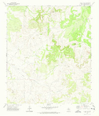
1972 Map of Susan Peak
USGS Topo · Published 1974About this map
Susan Peak rises above a landscape defined by industrial development and watershed drainage in Tom Green County. This early 1970s record shows a region heavily integrated with the oil industry, marked by numerous Oil Wells, a central Pipeline, and a Pumping Sta with a nearby Radio Tower. The terrain is cut by the paths of Lipan Creek and Pecan Creek, which provided the natural framework for early ranching and transit. For those researching local land use or infrastructure history, the presence of Doorkey Lane and scattered Gravel Pits offers specific points of reference for the road networks and resource extraction that supported the local economy during this era.
Find a feature on this map
12 named features on this map. Tap any name to fly to it.
Don’t see what you’re looking for? This feature index may not catch every label — zoom into the map to look around manually.
Map Details
Editions of this 1972 Susan Peak Map
2 editions found
Other maps of this area

1892 · San Angelo
USGS Topo · 1:125,000

1924 · San Angelo 2-c
USGS Topo · 1:48,000

1928 · Wall
USGS Topo · 1:62,500

1954 · San Angelo
USGS Topo · 1:250,000

1957 · Eola
USGS Topo · 1:62,500

1957 · Wall
USGS Topo · 1:62,500

1958 · San Angelo
USGS Topo · 1:250,000

1965 · San Angelo
USGS Topo · 1:250,000

1970 · Rocking Chair Ranch
USGS Topo · 1:24,000
1970 · Kickapoo Spring
USGS Topo · 1:24,000