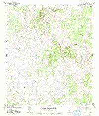
1972 Map of Susan Peak
USGS Topo · Published 1992About this map
Susan Peak dominates the northern reaches of this Tom Green County landscape, part of a terrain defined by the intermittent drainages of Pecan Creek and Dry Lipan Creek. The presence of Lipan Spring in the northeast corner suggests an essential water source in an area otherwise characterized by dry washes and high points like Cedar Knob. This era of the 1970s shows a landscape heavily utilized for resource extraction, evidenced by the numerous Oil Wells and Gravel Pits scattered throughout the quadrangle. Transportation is primarily limited to secondary routes and tracks, including the uniquely named Doorkey Lane which runs north-south through the western portion of the survey. Technical infrastructure, such as a Radio Tower and Pumping Sta, reflects the industrial operations supporting the local petroleum and ranching economy during this period.
Find a feature on this map
13 named features on this map. Tap any name to fly to it.
Don’t see what you’re looking for? This feature index may not catch every label — zoom into the map to look around manually.
Map Details
Editions of this 1972 Susan Peak Map
2 editions found
Other maps of this area

1892 · San Angelo
USGS Topo · 1:125,000

1924 · San Angelo 2-c
USGS Topo · 1:48,000

1928 · Wall
USGS Topo · 1:62,500

1954 · San Angelo
USGS Topo · 1:250,000

1957 · Eola
USGS Topo · 1:62,500

1957 · Wall
USGS Topo · 1:62,500

1958 · San Angelo
USGS Topo · 1:250,000

1965 · San Angelo
USGS Topo · 1:250,000

1970 · Rocking Chair Ranch
USGS Topo · 1:24,000
1970 · Kickapoo Spring
USGS Topo · 1:24,000