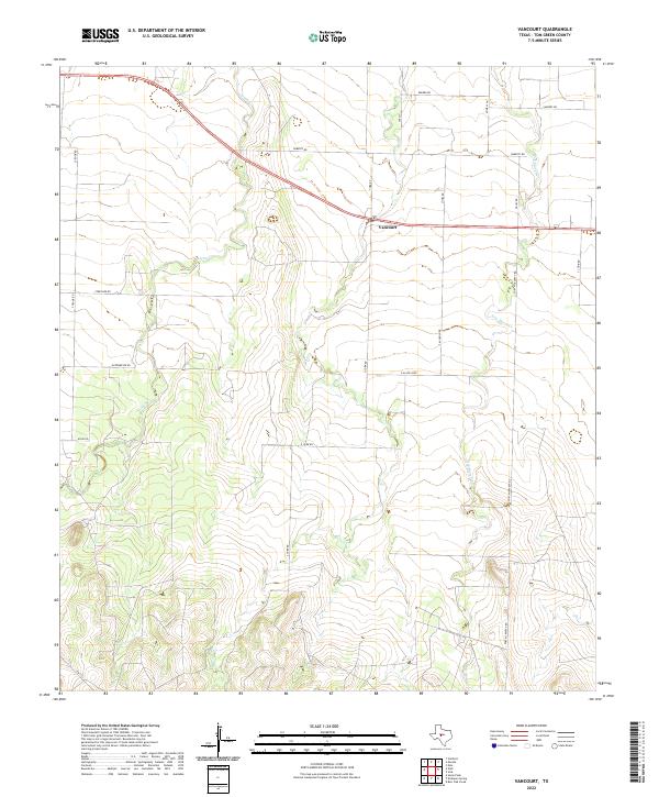
2022 Map of Vancourt
USGS Topo · Published 2022About this map
The small community of Vancourt serves as the focal point of this West Texas landscape, positioned where U.S. Route 87 cuts across the central Tom Green County plains. The area is defined by the winding drainage systems of Lipan Cr and Hog Marsh Cr, which create a complex network of relief across the otherwise steady terrain. This modern survey illustrates the persistent rural infrastructure of the region, where a grid of local roads like Roberts Rd and Streicher Rd connect long-standing ranching and agricultural properties. A notable historic artery, Fort McKavett Rd, runs north-to-south through the eastern portion of the quadrangle, preserving the name of the frontier-era military post that once anchored this part of the Texas frontier. The transition from established state routes like Fm 1223 to specialized local loops like E Allen Loop reflects the methodical parceling of the land for livestock and farming operations.
Find a feature on this map
22 named features on this map. Tap any name to fly to it.
Don’t see what you’re looking for? This feature index may not catch every label — zoom into the map to look around manually.
Map Details
Editions of this 2022 Vancourt Map
This is the sole edition of this map. No revisions or reprints were ever made.
Other maps of this area

1892 · San Angelo
USGS Topo · 1:125,000

1928 · Wall
USGS Topo · 1:62,500

1954 · San Angelo
USGS Topo · 1:250,000

1957 · Eola
USGS Topo · 1:62,500

1957 · Wall
USGS Topo · 1:62,500

1958 · San Angelo
USGS Topo · 1:250,000

1965 · San Angelo
USGS Topo · 1:250,000
1970 · Burr Oak Creek
USGS Topo · 1:24,000
1970 · Kickapoo Spring
USGS Topo · 1:24,000
1972 · Susan Peak
USGS Topo · 1:24,000