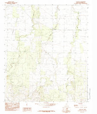
1984 Map of Vancourt
USGS Topo · Published 1984About this map
Lipan Flat characterizes this section of West Texas, a broad expanse of level terrain defined by seasonal watercourses and the small community of Vancourt. The landscape is etched by a drainage network including Lipan Creek in the west and Hog Marsh Creek to the east, while Snake Creek winds through the central portion of the quadrangle. These intermittent streams are critical markers in an otherwise uniform topography, traditionally supporting ranching and agricultural operations. Evidence of local industry is sparse but present, notably at a Gravel Pit near the northern boundary. The map reflects a moment in the mid-1980s when the rural character of Tom Green County remained largely defined by its natural hydrology and a handful of surveyed roads.
Find a feature on this map
6 named features on this map. Tap any name to fly to it.
Don’t see what you’re looking for? This feature index may not catch every label — zoom into the map to look around manually.
Map Details
Editions of this 1984 Vancourt Map
This is the sole edition of this map. No revisions or reprints were ever made.
Other maps of this area

1892 · San Angelo
USGS Topo · 1:125,000

1928 · Wall
USGS Topo · 1:62,500

1954 · San Angelo
USGS Topo · 1:250,000

1957 · Eola
USGS Topo · 1:62,500

1957 · Wall
USGS Topo · 1:62,500

1958 · San Angelo
USGS Topo · 1:250,000

1965 · San Angelo
USGS Topo · 1:250,000
1970 · Burr Oak Creek
USGS Topo · 1:24,000
1970 · Kickapoo Spring
USGS Topo · 1:24,000
1972 · Susan Peak
USGS Topo · 1:24,000