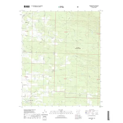
2020 Map of Vandervoort
USGS Topo · Published 2020About this map
Vandervoort and Hatfield serve as the primary hubs in this section of Polk County, where the transition from settled valley land to the protected wilderness of the Ouachita National Forest is clearly visible. The landscape is defined by a dense network of watercourses, including Sixmile Cr and Buffalo Cr, which carve through the terrain as it rises toward the eastern forest boundary.
Find a feature on this map
67 named features on this map. Tap any name to fly to it.
Don’t see what you’re looking for? This feature index may not catch every label — zoom into the map to look around manually.
Map Details
Editions of this 2020 Vandervoort Map
This is the sole edition of this map. No revisions or reprints were ever made.
Other maps of this area

1890 · Poteau Mountain
USGS Topo · 1:125,000

1899 · Poteau Mountain
USGS Topo · 1:125,000

1913 · De Queen
USGS Topo · 1:125,000

1950 · Mcalester
USGS Topo · 1:250,000

1958 · Mena
USGS Topo · 1:62,500

1958 · Potter
USGS Topo · 1:62,500

1958 · Zafra
USGS Topo · 1:24,000

1958 · Mena
USGS Topo · 1:24,000
1958 · Potter
USGS Topo · 1:24,000

1959 · Umpire
USGS Topo · 1:62,500