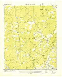
1935 Map of Vandever
USGS Topo · Published 1935About this map
Cumberland Plateau life in the mid-1930s is preserved here, centered on the Cumberland Homesteads project and the surrounding timbered uplands. The landscape is defined by the Tennessee Basin Divide, which separates the headwaters of the Sequatchie River from the sprawling drainage of Daddy Creek. This era captures the rural social infrastructure of the Plateau, from small post offices like Burke P O to community centers such as New Era Sch and Hale Chapel. Transportation routes such as the Alvin C York Highway and State Highway No 28 wind through complex terrain, passing landmarks like Blalock Knob and Morris Gap. The map documents a period of active New Deal era resettlement and infrastructure development, reflecting the Tennessee Valley Authority’s influence on the geography of the Cumberland and Bledsoe county line.
Find a feature on this map
47 named features on this map. Tap any name to fly to it.
Don’t see what you’re looking for? This feature index may not catch every label — zoom into the map to look around manually.
Map Details
Editions of this 1935 Vandever Map
This is the sole edition of this map. No revisions or reprints were ever made.
Other maps of this area

1887 · Kingston
USGS Topo · 1:125,000

1891 · Kingston
USGS Topo · 1:125,000

1892 · Pikeville
USGS Topo · 1:125,000

1893 · Kingston
USGS Topo · 1:125,000

1895 · Pikeville
USGS Topo · 1:125,000

1909 · Sequatchie Valley
USGS Topo · 1:62,500

1910 · Pikeville
USGS Topo · 1:62,500

1912 · Crossville
USGS Topo · 1:62,500

1935 · Melvine
USGS Topo · 1:24,000

1935 · Pennine
USGS Topo · 1:24,000