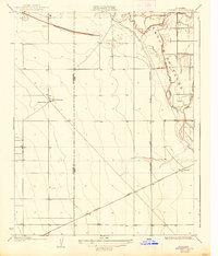
1926 Map of Vanguard
USGS Topo · Published 1938About this map
Laguna De Tache defines the eastern landscape of this San Joaquin Valley survey, where the winding channels of the Kings River and the North Fork Kings River diverge into a complex network of waterways including the Clarks Fork. The area reflects a transitional phase of California's agricultural and industrial development, anchored by the Southern Pacific railroad line cutting diagonally across the southwestern plains. Small rural centers like Lethent are documented alongside essential local infrastructure, including the Lethent School and San Jose School. The presence of an Oil Pumping Sta and the San Joaquin And Light Power Corporation power line route indicates the burgeoning energy infrastructure necessary to support the region's expanding land use in the mid-1920s. This survey records a moment when seasonal water management and rail transportation dictated the layout of valley life before modern highway expansion.
Find a feature on this map
12 named features on this map. Tap any name to fly to it.
Don’t see what you’re looking for? This feature index may not catch every label — zoom into the map to look around manually.
Map Details
Editions of this 1926 Vanguard Map
3 editions found
Other maps of this area

1912 · Coalinga
USGS Topo · 1:125,000

1924 · Riverdale
USGS Topo · 1:31,680

1926 · Lethent
USGS Topo · 1:31,680

1927 · Burrel
USGS Topo · 1:31,680

1927 · Riverdale
USGS Topo · 1:31,680

1927 · Lemoore
USGS Topo · 1:31,680

1929 · Stratford
USGS Topo · 1:31,680

1929 · Westhaven
USGS Topo · 1:31,680

1931 · Wheatville
USGS Topo · 1:31,680

1932 · West of Lethent
USGS Topo · 1:31,680