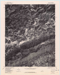
1976 Map of Varilla
USGS Topo · Published 1981About this map
Cumberland Mountain dominates the southern portion of this orthophoto, creating a natural divide in this portion of Bell County during the mid-1970s. The settlement of Varilla is situated in the northwest along the winding course of the river, while Caylor and Indian Creek mark the lower elevations to the southeast. Unlike traditional line-drawn maps, this aerial imagery reveals the physical scars of land use, where clearings for settlements like Calvin and Oaks contrast with the dense timber of the ridgelines.
Find a feature on this map
11 named features on this map. Tap any name to fly to it.
Don’t see what you’re looking for? This feature index may not catch every label — zoom into the map to look around manually.
Map Details
Editions of this 1976 Varilla Map
This is the sole edition of this map. No revisions or reprints were ever made.
Other maps of this area

1886 · Cumberland Gap
USGS Topo · 1:125,000

1887 · Jonesville
USGS Topo · 1:125,000

1888 · Cumberland Gap
USGS Topo · 1:125,000

1891 · Cumberland Gap
USGS Topo · 1:125,000

1891 · Jonesville
USGS Topo · 1:125,000

1903 · Harlan
USGS Topo · 1:48,000

1903 · Pineville
USGS Topo · 1:48,000

1903 · Middlesboro
USGS Topo · 1:48,000

1916 · Harlan
USGS Topo · 1:48,000

1919 · Harlan
USGS Topo · 1:62,500