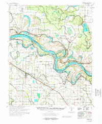
1978 Map of Varner
USGS Topo · Published 1978About this map
Arkansas River meanders define the border between Jefferson and Lincoln counties, carving a complex landscape of oxbows and cutoffs. The engineering of the Lock & Dam No 3 and various levee systems demonstrate the mid-century efforts to tame these waters, while State Prison Farm and Cummins State Prison occupy large tracts of the fertile alluvial plain. The Missouri Pacific railroad anchors the western settlements, serving the agricultural center of Grady and the smaller community of Varner.
Find a feature on this map
117 named features on this map. Tap any name to fly to it.
Don’t see what you’re looking for? This feature index may not catch every label — zoom into the map to look around manually.
Map Details
Editions of this 1978 Varner Map
This is the sole edition of this map. No revisions or reprints were ever made.
Other maps of this area

1935 · Feenyville
USGS Topo · 1:62,500

1935 · Altheimer
USGS Topo · 1:62,500

1935 · Varner
USGS Topo · 1:62,500

1935 · Noble Lake
USGS Topo · 1:62,500

1935 · Rotan
USGS Topo · 1:62,500

1935 · Red Fork
USGS Topo · 1:62,500

1935 · Gillett
USGS Topo · 1:62,500

1941 · De Witt
USGS Topo · 1:62,500

1941 · Goldman
USGS Topo · 1:62,500

1948 · Helena
USGS Topo · 1:250,000