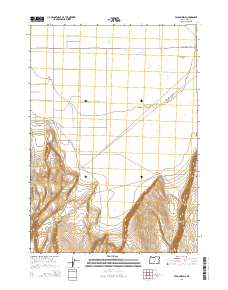
2014 Map of Vaughn Well
USGS Topo · Published 2014About this map
Fort Rock Valley defines the high-desert landscape in this section of Lake County, where the topography transitions from the flat expanses of the valley floor to the steep verticality of the Burma Rim. The map documents a sparsely settled region organized around long-standing ranching and water access points, most notably Vaughn Well. The infrastructure is dominated by a grid-like network of rural transit corridors, including the Christmas Valley Hwy and 3 Mile Rd, which cut across the high plains.
Find a feature on this map
12 named features on this map. Tap any name to fly to it.
Don’t see what you’re looking for? This feature index may not catch every label — zoom into the map to look around manually.
Map Details
Editions of this 2014 Vaughn Well Map
This is the sole edition of this map. No revisions or reprints were ever made.
Other maps of this area

1955 · Crescent
USGS Topo · 1:250,000

1957 · Crescent
USGS Topo · 1:250,000

1958 · Crescent
USGS Topo · 1:250,000

1970 · Crescent
USGS Topo · 1:250,000

1981 · Fossil Lake
USGS Topo · 1:24,000

1981 · Sand Rock
USGS Topo · 1:24,000

1982 · Christmas Lake
USGS Topo · 1:24,000
1985 · Fire Lake
USGS Topo · 1:24,000

1986 · St. Patrick Mtn.
USGS Topo · 1:24,000
1986 · Fandango Canyon
USGS Topo · 1:24,000