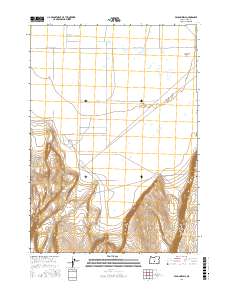
2017 Map of Vaughn Well
USGS Topo · Published 2017About this map
Christmas Lake Valley sits at the northern edge of this high desert landscape in Lake County, where the flat expanse of Fort Rock Valley meets the sharp topographic rise of Burma Rim. This 2017 survey shows the geometric layout of the region's agricultural and ranching infrastructure, defined by long, straight thoroughfares like Christmas Valley Hwy and 3 Mile Rd. The remote character of the area is underscored by the sparse naming of water sources, such as Vaughn Well, which serves as a critical landmark in this arid basin. The map illustrates a clear transition from the low-lying valley floor to the elevated plateaus and escarpments to the south, highlighting how the physical geography dictated the placement of roads and homesteads in this part of Oregon.
Find a feature on this map
11 named features on this map. Tap any name to fly to it.
Don’t see what you’re looking for? This feature index may not catch every label — zoom into the map to look around manually.
Map Details
Editions of this 2017 Vaughn Well Map
This is the sole edition of this map. No revisions or reprints were ever made.
Other maps of this area

1955 · Crescent
USGS Topo · 1:250,000

1957 · Crescent
USGS Topo · 1:250,000

1958 · Crescent
USGS Topo · 1:250,000

1970 · Crescent
USGS Topo · 1:250,000

1981 · Fossil Lake
USGS Topo · 1:24,000

1981 · Sand Rock
USGS Topo · 1:24,000

1982 · Christmas Lake
USGS Topo · 1:24,000
1985 · Fire Lake
USGS Topo · 1:24,000

1986 · St. Patrick Mtn.
USGS Topo · 1:24,000
1986 · Fandango Canyon
USGS Topo · 1:24,000