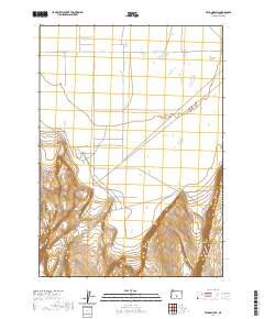
2020 Map of Vaughn Well
USGS Topo · Published 2020About this map
Christmas Lake Valley and Fort Rock Valley meet in this high-desert landscape of Lake County, where the transition from flat valley floors to the dramatic elevation of Burma Rim is clearly defined. The settlement of Vaughn Well sits at the base of this rising terrain, serving as a focal point for local transportation routes like the Christmas Valley Hwy and 3 Mile Rd. This 2020 survey illustrates how modern infrastructure interacts with the ancient geological features of the Oregon interior, mapping the precise contours of the escarpments that bound these desert basins.
Find a feature on this map
11 named features on this map. Tap any name to fly to it.
Don’t see what you’re looking for? This feature index may not catch every label — zoom into the map to look around manually.
Map Details
Editions of this 2020 Vaughn Well Map
This is the sole edition of this map. No revisions or reprints were ever made.
Other maps of this area

1955 · Crescent
USGS Topo · 1:250,000

1957 · Crescent
USGS Topo · 1:250,000

1958 · Crescent
USGS Topo · 1:250,000

1970 · Crescent
USGS Topo · 1:250,000

1981 · Fossil Lake
USGS Topo · 1:24,000

1981 · Sand Rock
USGS Topo · 1:24,000

1982 · Christmas Lake
USGS Topo · 1:24,000
1985 · Fire Lake
USGS Topo · 1:24,000

1986 · St. Patrick Mtn.
USGS Topo · 1:24,000
1986 · Fandango Canyon
USGS Topo · 1:24,000