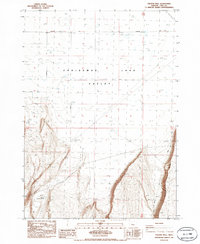
1986 Map of Vaughn Well
USGS Topo · Published 1986About this map
Christmas Lake Valley defines the northern reaches of this high desert landscape in Lake County, Oregon, where the flat, arid basin floor is marked by numerous Alkali Flats and scattered water sources. This 1986 provisional survey captures the remote character of the region as it was in the early 1980s, emphasizing the sparse infrastructure required for ranching and utility transport. Central to the map's geography is Vaughn Well, a critical landmark in this dry terrain, while further south, the presence of unidentified Ruins and the County Waterhole No 16 point to the human effort to sustain activity in the basin. The landscape is bisected by large-scale infrastructure, including a Steel Tower Powerline and a Trans Line. Transportation is limited to a few arterial routes like the Wagontire Road and Burma Road, providing essential access through the shifting elevations and gravel pits of the high desert.
Find a feature on this map
15 named features on this map. Tap any name to fly to it.
Don’t see what you’re looking for? This feature index may not catch every label — zoom into the map to look around manually.
Map Details
Editions of this 1986 Vaughn Well Map
This is the sole edition of this map. No revisions or reprints were ever made.
Other maps of this area

1955 · Crescent
USGS Topo · 1:250,000

1957 · Crescent
USGS Topo · 1:250,000

1958 · Crescent
USGS Topo · 1:250,000

1970 · Crescent
USGS Topo · 1:250,000

1981 · Fossil Lake
USGS Topo · 1:24,000

1981 · Sand Rock
USGS Topo · 1:24,000

1982 · Christmas Lake
USGS Topo · 1:24,000
1985 · Fire Lake
USGS Topo · 1:24,000

1986 · St. Patrick Mtn.
USGS Topo · 1:24,000
1986 · Fandango Canyon
USGS Topo · 1:24,000