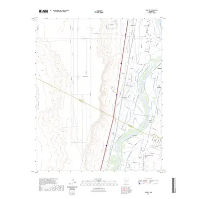
2023 Map of Veguita
USGS Topo · Published 2023About this map
The Rio Grande corridor south of Albuquerque reveals a complex network of traditional irrigation and land management in this modern survey. The landscape is defined by an intricate system of acequias and drains, such as the Arroyos Ditch, Sabinal Ditch, and Casa Colorada Canal, which sustain the agricultural ribbon between the river and the arid bluffs. Small communities and family-named roads, including Pueblitos, Jarales, and Bosque, trace the fertile valley floor. The boundary between Valencia and Socorro Counties bisects the area, highlighting the proximity of these riverfront settlements. Local heritage is preserved in several burial grounds like the Veguita Memorial Cem and San Antonio Cem, while the Skywagon Farm Airport and Flying H Airport indicate the modern integration of aviation into this rural landscape. This study details the intersection of historic water rights and contemporary infrastructure in the heart of the Middle Rio Grande Valley.
Find a feature on this map
102 named features on this map. Tap any name to fly to it.
Don’t see what you’re looking for? This feature index may not catch every label — zoom into the map to look around manually.
Map Details
Editions of this 2023 Veguita Map
This is the sole edition of this map. No revisions or reprints were ever made.
Other maps of this area

1916 · La Joya
USGS Topo · 1:125,000

1952 · La Joya NW
USGS Topo · 1:24,000

1952 · Belen SW
USGS Topo · 1:24,000

1952 · Black Butte
USGS Topo · 1:24,000

1952 · Belen
USGS Topo · 1:24,000

1952 · Turn
USGS Topo · 1:24,000

1952 · Veguita
USGS Topo · 1:24,000

1952 · Belen NW
USGS Topo · 1:24,000

1952 · Tome
USGS Topo · 1:24,000

1952 · Abeytas
USGS Topo · 1:24,000