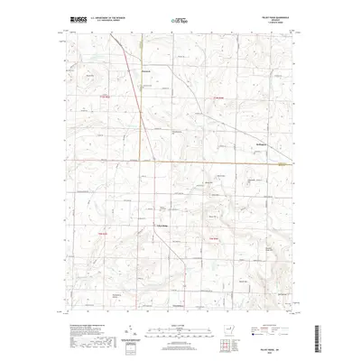
2020 Map of Velvet Ridge
USGS Topo · Published 2020About this map
Batesville Blvd serves as the central artery for this portion of the Arkansas landscape, connecting several small communities where White and Jackson Counties meet. The settlement of Velvet Ridge sits at a crossroads near Velvet Ridge Cemetery, while further north, Denmark is situated near the Bethlehem Cemetery. The terrain is defined by a series of distinct elevations, including Throckmorton Hill, Soapstone Hill, and the more prominent Buzzard Roost Mountain to the southeast. Waterways such as Fourmile Creek and Glaise Creek drain the undulating hills, which are also home to curiously named hollows like Huckleberry Hollow and Wolf Hollow. To the east, the community of Heffington is identified near Caplener Branch, while the oddly named Twentythree appears in the southern reaches, providing a clear view of rural development patterns in the early twenty-first century.
Find a feature on this map
65 named features on this map. Tap any name to fly to it.
Don’t see what you’re looking for? This feature index may not catch every label — zoom into the map to look around manually.
Map Details
Editions of this 2020 Velvet Ridge Map
This is the sole edition of this map. No revisions or reprints were ever made.
Other maps of this area

1890 · Batesville
USGS Topo · 1:125,000

1891 · Batesville
USGS Topo · 1:125,000

1935 · Newport
USGS Topo · 1:62,500

1935 · Augusta
USGS Topo · 1:62,500

1935 · Bald Knob
USGS Topo · 1:62,500

1953 · Memphis
USGS Topo · 1:250,000

1956 · Memphis
USGS Topo · 1:250,000

1957 · Augusta
USGS Topo · 1:62,500
1962 · Olyphant
USGS Topo · 1:24,000
1962 · Newport
USGS Topo · 1:62,500