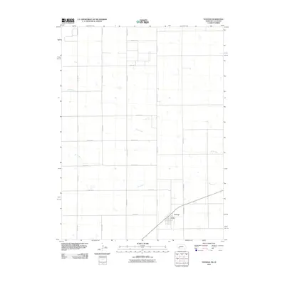
2010 Map of Venango
USGS Topo · Published 2010About this map
Venango serves as the primary hub of activity in this corner of Perkins County, anchored by the Venango Post Office and a network of surveyed section roads. The landscape is defined by the ephemeral drainage patterns of the High Plains, where Spring Creek and Sand Creek wind across the terrain. This 2010 survey illustrates a strictly grid-based agricultural environment, where the precise alignment of thoroughfares like Road West Rd and County Rd-18 dictates the movement of people and goods across the Nebraska-Colorado borderlands. The map reveals how water and transportation infrastructure remain the critical scaffolding for life in this sparsely populated agricultural region.
Find a feature on this map
17 named features on this map. Tap any name to fly to it.
Don’t see what you’re looking for? This feature index may not catch every label — zoom into the map to look around manually.
Map Details
Editions of this 2010 Venango Map
This is the sole edition of this map. No revisions or reprints were ever made.
Other maps of this area

1954 · Sterling
USGS Topo · 1:250,000

1954 · McCook
USGS Topo · 1:250,000

1957 · McCook
USGS Topo · 1:250,000

1958 · McCook
USGS Topo · 1:250,000

1958 · Sterling
USGS Topo · 1:250,000

1961 · Brandon NW
USGS Topo · 1:24,000

1961 · Lamar NW
USGS Topo · 1:24,000

1961 · Brandon
USGS Topo · 1:24,000

1962 · Venango SW
USGS Topo · 1:24,000
1962 · Venango NE
USGS Topo · 1:24,000