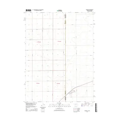
2014 Map of Venango
USGS Topo · Published 2014About this map
Venango sits at the eastern edge of this 2014 survey, positioned where the high plains of Nebraska meet the Colorado state line. The town's grid, featuring Mercer St and Washington St, serves as a focal point for the surrounding agricultural landscape. This borderland is defined by a strict section-line road network, including Co Road 63.2 which runs directly along the Colorado Nebraska boundary. The natural drainage of the region is traced by the seasonal paths of Spring Creek and Sand Creek, which wind through the terrain otherwise dominated by the geometric precision of the Public Land Survey System. The transition between Sedgwick and Perkins counties is clearly delineated, illustrating the administrative divisions that govern these western rangelands.
Find a feature on this map
29 named features on this map. Tap any name to fly to it.
Don’t see what you’re looking for? This feature index may not catch every label — zoom into the map to look around manually.
Map Details
Editions of this 2014 Venango Map
This is the sole edition of this map. No revisions or reprints were ever made.
Other maps of this area

1954 · Sterling
USGS Topo · 1:250,000

1954 · McCook
USGS Topo · 1:250,000

1957 · McCook
USGS Topo · 1:250,000

1958 · McCook
USGS Topo · 1:250,000

1958 · Sterling
USGS Topo · 1:250,000

1961 · Brandon NW
USGS Topo · 1:24,000

1961 · Lamar NW
USGS Topo · 1:24,000

1961 · Brandon
USGS Topo · 1:24,000

1962 · Venango SW
USGS Topo · 1:24,000
1962 · Venango NE
USGS Topo · 1:24,000