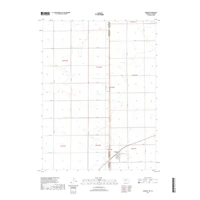
2017 Map of Venango
USGS Topo · Published 2017About this map
The high plains of the Nebraska-Colorado border define this landscape, where the small community of Venango serves as a lone hub of activity in the southwest corner. The village is neatly platted with streets such as Mercer St, Pennsylvania Ave, and Allegheny Ave, reflecting a structured townsite plan typical of the region's agricultural centers. Outside the town limits, the terrain is shaped by the intermittent flow of Spring Cr and Sand Cr, which cut through the open country.
Find a feature on this map
36 named features on this map. Tap any name to fly to it.
Don’t see what you’re looking for? This feature index may not catch every label — zoom into the map to look around manually.
Map Details
Editions of this 2017 Venango Map
This is the sole edition of this map. No revisions or reprints were ever made.
Other maps of this area

1954 · Sterling
USGS Topo · 1:250,000

1954 · McCook
USGS Topo · 1:250,000

1957 · McCook
USGS Topo · 1:250,000

1958 · McCook
USGS Topo · 1:250,000

1958 · Sterling
USGS Topo · 1:250,000

1961 · Brandon NW
USGS Topo · 1:24,000

1961 · Lamar NW
USGS Topo · 1:24,000

1961 · Brandon
USGS Topo · 1:24,000

1962 · Venango SW
USGS Topo · 1:24,000
1962 · Venango NE
USGS Topo · 1:24,000