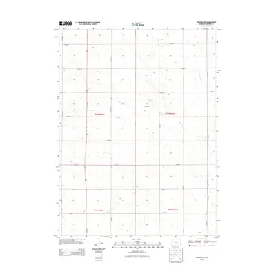
2013 Map of Venango SW
USGS Topo · Published 2013About this map
Sand Draw and the seasonal drainages of northeastern Colorado define this rural landscape in Sedgwick County. The map area is characterized by a disciplined grid of county roads, such as Co Road 16 and Co Road 53, which support the region's agricultural layout. A primary north-south artery, Us-385 N, bisects the western half of the territory, providing the essential link between the high plains and the Platte River valley to the north. Hydrological features are sparse but critical to this environment, notably the Sand Cr Reservoir and the winding course of Spring Creek. These landmarks, along with Sand Creek, indicate the natural drainage patterns that have historically influenced land use and ranching boundaries in this corner of the state near the Nebraska border.
Find a feature on this map
24 named features on this map. Tap any name to fly to it.
Don’t see what you’re looking for? This feature index may not catch every label — zoom into the map to look around manually.
Map Details
Editions of this 2013 Venango SW Map
This is the sole edition of this map. No revisions or reprints were ever made.
Other maps of this area

1952 · Julesburg SE
USGS Topo · 1:24,000

1953 · Julesburg
USGS Topo · 1:24,000

1954 · Sterling
USGS Topo · 1:250,000

1958 · Sterling
USGS Topo · 1:250,000

1962 · Venango SW
USGS Topo · 1:24,000
1962 · Venango NE
USGS Topo · 1:24,000

1962 · Holyoke NE
USGS Topo · 1:24,000

1962 · Amherst
USGS Topo · 1:24,000
1962 · Venango NW
USGS Topo · 1:24,000

1962 · Amherst NE
USGS Topo · 1:24,000