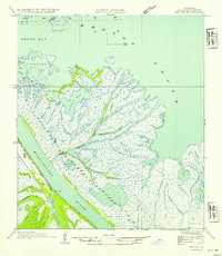
1954 Map of Venice
USGS Topo · Published 1954About this map
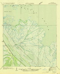
The settlement of Venice stands at a critical transition point where the Mississippi River begins its final sprawl into the Gulf of Mexico. This mid-century view shows a landscape of intricate hydrology, dominated by the active deltaic processes of the Plaquemines Parish coastline. At a location known as The Jump, the river's main channel interacts with a complex network of distributaries including Tiger Pass and Spanish Pass.
Find a feature on this map
32 named features on this map. Tap any name to fly to it.
Don’t see what you’re looking for? This feature index may not catch every label — zoom into the map to look around manually.
Map Details
Editions of this 1954 Venice Map
This is the sole edition of this map. No revisions or reprints were ever made.
Other maps of this area
1893 · East Delta
USGS Topo · 1:62,500
1893 · Forts
USGS Topo · 1:62,500
1893 · West Delta
USGS Topo · 1:62,500

1935 · Taylor Pass
USGS Topo · 1:31,680

1946 · Pass Tante Phine
USGS Topo · 1:31,680

1947 · Pass A Loutre West
USGS Topo · 1:31,680
1947 · Venice
USGS Topo · 1:31,680

1947 · Fort St. Philip
USGS Topo · 1:31,680

1947 · Main Pass
USGS Topo · 1:31,680

1948 · Forts
USGS Topo · 1:62,500