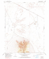
1968 Map of Ventosa
USGS Topo · Published 1981About this map
Ventosa sits as a lonely waypoint along the rail line in this high-desert landscape of eastern Nevada. The terrain is defined by two major geological depressions, Clover Valley and Independence Valley, which are separated by the rising elevations of Black Ridge and the prominent heights of Spruce Mtn Ridge. This 1968 field-checked environment reveals the hydrologic patterns of the Great Basin, where seasonal water features like The Slough and Little Lake dominate the valley floors.
Find a feature on this map
11 named features on this map. Tap any name to fly to it.
Don’t see what you’re looking for? This feature index may not catch every label — zoom into the map to look around manually.
Map Details
Editions of this 1968 Ventosa Map
2 editions found
Other maps of this area

1953 · Spruce Mountain
USGS Topo · 1:62,500

1953 · Spruce Mountain 4
USGS Topo · 1:62,500

1955 · Elko
USGS Topo · 1:250,000

1958 · Elko
USGS Topo · 1:250,000

1962 · Elko
USGS Topo · 1:250,000

1965 · Elko
USGS Topo · 1:250,000

1968 · Independence Valley SW
USGS Topo · 1:24,000

1968 · Snow Water Lake
USGS Topo · 1:24,000

1968 · Ventosa
USGS Topo · 1:24,000
1968 · Snow Water Lake NE
USGS Topo · 1:24,000