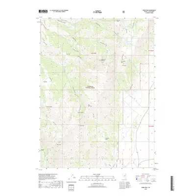
2018 Map of Verdi Peak
USGS Topo · Published 2018About this map
Verdi Peak and the high ridges of the Ruby Mountains dominate this 2018 survey within the Humboldt National Forest. The landscape is defined by its dramatic verticality, with named summits including Smith Peak, Horse Mtn, and Bald Mtn rising above deep drainages such as Conrad Canyon and Lamoille Canyon. Alpine water bodies are scattered throughout the high basins, from Verdi Lake near the peak to Robinson Lake, Soldier Lakes, and the Hidden Lakes in the north.
Find a feature on this map
56 named features on this map. Tap any name to fly to it.
Don’t see what you’re looking for? This feature index may not catch every label — zoom into the map to look around manually.
Map Details
Editions of this 2018 Verdi Peak Map
This is the sole edition of this map. No revisions or reprints were ever made.
Other maps of this area

1935 · Halleck
USGS Topo · 1:125,000

1955 · Elko
USGS Topo · 1:250,000

1958 · Elko
USGS Topo · 1:250,000

1962 · Elko
USGS Topo · 1:250,000

1962 · Lamoille
USGS Topo · 1:62,500

1965 · Elko
USGS Topo · 1:250,000
1969 · Secret Valley
USGS Topo · 1:24,000
1970 · Soldier Peak
USGS Topo · 1:24,000
1971 · Halleck SW
USGS Topo · 1:24,000
1984 · Ruby City Creek
USGS Topo · 1:24,000