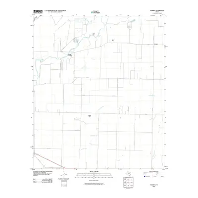
2010 Map of Veribest
USGS Topo · Published 2010About this map
The Lipan Flat dominates the central portion of this landscape east of San Angelo, where the agricultural grid meets the winding course of the Concho River. This 2010 survey illustrates the water management infrastructure critical to Tom Green County, highlighting Kaase Dam and Johnson Dam, alongside the San Angelo Sewage Ponds at the river's upper reach. The small settlement of Veribest sits at a crossroads in the northeast, serving as a focal point for the surrounding rural road network. Below the river, the terrain is defined by drainage patterns including Ninemile Creek and Dry Lipan Creek. Local landmarks like Sixmile Crossing reflect the historic connectivity of a region shaped by both its dry plains and vital riparian corridors.
Find a feature on this map
39 named features on this map. Tap any name to fly to it.
Don’t see what you’re looking for? This feature index may not catch every label — zoom into the map to look around manually.
Map Details
Editions of this 2010 Veribest Map
This is the sole edition of this map. No revisions or reprints were ever made.
Other maps of this area

1891 · Hayrick
USGS Topo · 1:125,000

1892 · San Angelo
USGS Topo · 1:125,000

1894 · Hayrick
USGS Topo · 1:125,000

1924 · San Angelo 2-c
USGS Topo · 1:48,000

1924 · San Angelo 2-b
USGS Topo · 1:48,000

1928 · Wall
USGS Topo · 1:62,500

1954 · San Angelo
USGS Topo · 1:250,000

1957 · Eola
USGS Topo · 1:62,500

1957 · Miles
USGS Topo · 1:62,500
1957 · San Angelo South
USGS Topo · 1:24,000