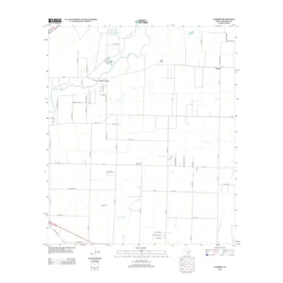
2012 Map of Veribest
USGS Topo · Published 2012About this map
The Concho River winds through the northern reaches of this West Texas landscape, marking a transition from the riparian corridor to the broad, agricultural expanses of Lipan Flat. Near the river's edge, the small community of Veribest and the historic Sixmile Crossing anchor the local road network, while the southern portion of the quadrangle is defined by the ephemeral drainages of Ninemile Cr and Dry Lipan Cr. A distinct concentration of rural infrastructure is visible around Waterloo in the south, contrasting with the large-scale municipal utility footprint of the San Angelo Sewage Ponds to the northwest. This 2012 survey illustrates the enduring agricultural layout of Tom Green County, where farm-to-market roads like FM-380 and FM-388 connect isolated farmsteads and rural dwellings across the expansive terrain.
Find a feature on this map
56 named features on this map. Tap any name to fly to it.
Don’t see what you’re looking for? This feature index may not catch every label — zoom into the map to look around manually.
Map Details
Editions of this 2012 Veribest Map
This is the sole edition of this map. No revisions or reprints were ever made.
Other maps of this area

1891 · Hayrick
USGS Topo · 1:125,000

1892 · San Angelo
USGS Topo · 1:125,000

1894 · Hayrick
USGS Topo · 1:125,000

1924 · San Angelo 2-c
USGS Topo · 1:48,000

1924 · San Angelo 2-b
USGS Topo · 1:48,000

1928 · Wall
USGS Topo · 1:62,500

1954 · San Angelo
USGS Topo · 1:250,000

1957 · Eola
USGS Topo · 1:62,500

1957 · Miles
USGS Topo · 1:62,500
1957 · San Angelo South
USGS Topo · 1:24,000