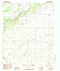
1984 Map of Veribest
USGS Topo · Published 1984About this map
Veribest serves as the primary settlement on this West Texas landscape, positioned within the fertile agricultural expanse of the Lipan Flat. The central feature of the area's development is the extensive irrigation network, anchored by the Main Canal, which cuts across the terrain to support local ranching and farming operations. The Concho River winds through the northern portion of the map, providing a vital natural water source that contrasts with the seasonal drainage patterns of Ninemile Creek and Dry Lipan Creek. The rectilinear grid of roads and survey lines illustrates a highly organized approach to land use typical of this portion of Tom Green County. This survey reflects the region's mid-1970s character, documenting the rural infrastructure and water management systems that sustained these high-plains communities.
Find a feature on this map
6 named features on this map. Tap any name to fly to it.
Don’t see what you’re looking for? This feature index may not catch every label — zoom into the map to look around manually.
Map Details
Editions of this 1984 Veribest Map
This is the sole edition of this map. No revisions or reprints were ever made.
Other maps of this area

1891 · Hayrick
USGS Topo · 1:125,000

1892 · San Angelo
USGS Topo · 1:125,000

1894 · Hayrick
USGS Topo · 1:125,000

1924 · San Angelo 2-c
USGS Topo · 1:48,000

1924 · San Angelo 2-b
USGS Topo · 1:48,000

1928 · Wall
USGS Topo · 1:62,500

1954 · San Angelo
USGS Topo · 1:250,000

1957 · Eola
USGS Topo · 1:62,500

1957 · Miles
USGS Topo · 1:62,500
1957 · San Angelo South
USGS Topo · 1:24,000