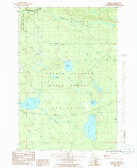
1985 Map of Vermilac
USGS Topo · Published 1986About this map
Sturgeon River flows across the northern reaches of this Baraga County landscape, characterized by the dense timberlands of the Baraga State Forest and Copper Country State Forest. The geography is defined by its complex hydrology, featuring numerous isolated basins such as King Lake, Worm Lake, and Parent Lake. The small settlement of Vermilac is situated near the Vermilac River, reflecting the area's history as a remote interior location. A network of creeks, including Hickey Creek and Pelkie Creek, drain the high ground, while landmarks like Upper Falls on the Sturgeon River provide specific navigational points. Several gravel pits suggest localized resource extraction within the township of Covington, which encompasses much of the central and southern portions of the survey area.
Find a feature on this map
23 named features on this map. Tap any name to fly to it.
Don’t see what you’re looking for? This feature index may not catch every label — zoom into the map to look around manually.
Map Details
Editions of this 1985 Vermilac Map
This is the sole edition of this map. No revisions or reprints were ever made.
Other maps of this area

1895 · Ned Lake
USGS Topo · 1:62,500

1895 · Perch Lake
USGS Topo · 1:62,500

1954 · Perch Lake
USGS Topo · 1:62,500

1954 · Sidnaw
USGS Topo · 1:62,500

1955 · Ned Lake
USGS Topo · 1:62,500

1955 · Herman
USGS Topo · 1:62,500

1958 · Iron River
USGS Topo · 1:250,000

1960 · Iron River
USGS Topo · 1:250,000

1961 · Iron River
USGS Topo · 1:250,000

1967 · Iron River
USGS Topo · 1:250,000