
1951 Map of Vermilion
USGS Topo · Published 1955About this map
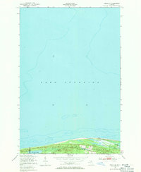
Lake Superior dominates the northern landscape of this coastal survey, where the shoreline of the Upper Peninsula meets the vast waters of the Whitefish Bay area. The settlement of Vermilion serves as the primary landmark on this stretch of coast, situated near a prominent Tower and nestled within the protected lands of the Whitefish State Forest. The geography is defined by a narrow strip of land between the Great Lake and a series of inland water bodies, including Browns Lake, Twomile Lake, and Weatherhogs Lake. The boundary between Luce and Chippewa Counties cuts through this area, as does the line for McMillan. This 1950s documentation, based on Army Map Service data, captures a quiet, wooded coastal environment where drainage is managed by small coastal streams like Browns Creek and Weatherhogs Creek.
Find a feature on this map
11 named features on this map. Tap any name to fly to it.
Don’t see what you’re looking for? This feature index may not catch every label — zoom into the map to look around manually.
Map Details
Editions of this 1951 Vermilion Map
2 editions found
Other maps of this area

1951 · Vermilion SE
USGS Topo · 1:24,000

1951 · Shelldrake
USGS Topo · 1:24,000

1951 · Sheephead Lake
USGS Topo · 1:24,000

1951 · Shelldrake
USGS Topo · 1:62,500

1954 · Sault Sainte Marie
USGS Topo · 1:250,000

1956 · Sault Sainte Marie
USGS Topo · 1:250,000

1957 · Sault Sainte Marie
USGS Topo · 1:250,000

1958 · Sault Sainte Marie
USGS Topo · 1:250,000
1968 · Betsy Lake North
USGS Topo · 1:24,000
1985 · Two Hearted River
USGS Topo · 1:100,000
Featured Places
- Whitefish Township, MI
- Vermilion, Whitefish Township
- McMillan Township, MI
- Chippewa County, MI
- Luce County, MI