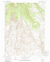
1964 Map of Vernal NW
USGS Topo · Published 1984About this map
Coal Mine Basin dominates the northeastern corner of this high-desert landscape in Uintah County, providing a clear view of the region's mid-century industrial and grazing infrastructure. The topography is defined by the drainage systems of Twelvemile Wash and Halfway Hollow, where intermittent water sources like Cottonwood Spring and Spring were essential for local operations. A Military Reservation Boundary cuts across the northern terrain, signaling federal land use patterns common in this part of Utah during the mid-1960s. Evidence of resource extraction is visible through multiple Mines and a Quarry, while the presence of a Pipeline and the CCC Tank indicates the development of water and energy transport systems across the arid basins. These features, connected by a network of Jeep Trails, reflect a landscape utilized for its raw materials and managed for livestock in the years following the Second World War.
Find a feature on this map
15 named features on this map. Tap any name to fly to it.
Don’t see what you’re looking for? This feature index may not catch every label — zoom into the map to look around manually.
Map Details
Editions of this 1964 Vernal NW Map
2 editions found
Other maps of this area

1885 · Ashley
USGS Topo · 1:250,000

1906 · Marsh Peak
USGS Topo · 1:125,000

1908 · Marsh Peak
USGS Topo · 1:125,000

1917 · Vernal
USGS Topo · 1:125,000

1954 · Vernal
USGS Topo · 1:250,000

1958 · Vernal
USGS Topo · 1:250,000

1960 · Vernal
USGS Topo · 1:250,000

1964 · Vernal NE
USGS Topo · 1:24,000
1964 · Fort Duchesne
USGS Topo · 1:24,000

1964 · Lapoint
USGS Topo · 1:24,000