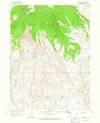
1964 Map of Vernal NW
USGS Topo · Published 1966About this map
Military Reservation Boundary 1873 cuts across the northern reaches of this territory, marking a 19th-century administrative line that persists through the mid-1960s. The landscape is defined by the stark transition from the high Coal Mine Basin in the northeast to the deeply eroded drainages of Halfway Hollow and Twelvemile Wash. These watercourses create a complex network of ridgelines and ravines, where human activity is limited to resource extraction and cattle management. Small-scale industrial efforts are visible in the clusters of Mines and a Quarry near the basin, while the presence of a CCC Tank points to infrastructure developed during the New Deal era to manage water in this arid environment. A network of Jeep Trails provides the primary access through the broken terrain, illustrating how much of this Uintah County back-country remained accessible only by specialized vehicle decades after the initial frontier period.
Find a feature on this map
14 named features on this map. Tap any name to fly to it.
Don’t see what you’re looking for? This feature index may not catch every label — zoom into the map to look around manually.
Map Details
Editions of this 1964 Vernal NW Map
2 editions found
Other maps of this area

1885 · Ashley
USGS Topo · 1:250,000

1906 · Marsh Peak
USGS Topo · 1:125,000

1908 · Marsh Peak
USGS Topo · 1:125,000

1917 · Vernal
USGS Topo · 1:125,000

1954 · Vernal
USGS Topo · 1:250,000

1958 · Vernal
USGS Topo · 1:250,000

1960 · Vernal
USGS Topo · 1:250,000

1964 · Vernal NE
USGS Topo · 1:24,000
1964 · Fort Duchesne
USGS Topo · 1:24,000

1964 · Lapoint
USGS Topo · 1:24,000