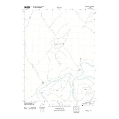
2011 Map of Vernal SE
USGS Topo · Published 2011About this map
The Green River carves a dramatic path through this Uintah County landscape, forming distinct riverine features such as The Stirrup and the wide arc of Horseshoe Bend. This area south of Vernal is characterized by a mix of ranching infrastructure and scientific research, notably home to the Uinta Basin Seismological Observatory. The local economy of the early 21st century is reflected in the managed lands of McCoy Flat and various livestock enclosures like the McCoy Flat Corral and Youngs Cow Corral. Water management is central to the valley's development, evidenced by the Highline Canal and the lush riparian zone at Hamacker Bottoms. Navigating the varied terrain is possible through a network of local routes including McCoy Flat Rd and Baeser Rd, which connect the upland McCoy Knolls to the river's edge at Collier Hole.
Find a feature on this map
20 named features on this map. Tap any name to fly to it.
Don’t see what you’re looking for? This feature index may not catch every label — zoom into the map to look around manually.
Map Details
Editions of this 2011 Vernal SE Map
This is the sole edition of this map. No revisions or reprints were ever made.
Other maps of this area

1885 · Ashley
USGS Topo · 1:250,000

1907 · Jensen
USGS Topo · 1:125,000

1910 · Jensen
USGS Topo · 1:125,000

1917 · Vernal
USGS Topo · 1:125,000

1954 · Vernal
USGS Topo · 1:250,000

1958 · Vernal
USGS Topo · 1:250,000

1960 · Vernal
USGS Topo · 1:250,000

1964 · Vernal NE
USGS Topo · 1:24,000

1964 · Brennan Basin
USGS Topo · 1:24,000
1964 · Vernal SW
USGS Topo · 1:24,000