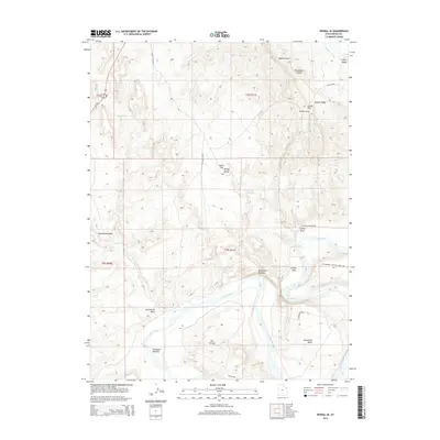
2014 Map of Vernal SE
USGS Topo · Published 2014About this map
The Green River meanders through this section of the Uinta Basin, creating a series of dramatic geographic features including the sharp loop at Horseshoe Bend and the abandoned river channel known as The Stirrup. To the north, the elevation rises sharply toward Asphalt Ridge, a prominent geological formation that overlooks the drainage systems of Mantle Gulch and Rasmussen Hollow. This landscape is defined by the contrast between the fertile alluvial plains of Hamacker Bottoms and the arid, dissected uplands of McCoy Flat. Agricultural and industrial infrastructure is evident through the presence of the Highline Canal and the Cement Reservoir, while the presence of Us-191 and McCoy Flats Rd indicates the primary corridors for modern transport and land management in this high-desert environment.
Find a feature on this map
27 named features on this map. Tap any name to fly to it.
Don’t see what you’re looking for? This feature index may not catch every label — zoom into the map to look around manually.
Map Details
Editions of this 2014 Vernal SE Map
This is the sole edition of this map. No revisions or reprints were ever made.
Other maps of this area

1885 · Ashley
USGS Topo · 1:250,000

1907 · Jensen
USGS Topo · 1:125,000

1910 · Jensen
USGS Topo · 1:125,000

1917 · Vernal
USGS Topo · 1:125,000

1954 · Vernal
USGS Topo · 1:250,000

1958 · Vernal
USGS Topo · 1:250,000

1960 · Vernal
USGS Topo · 1:250,000

1964 · Vernal NE
USGS Topo · 1:24,000

1964 · Brennan Basin
USGS Topo · 1:24,000
1964 · Vernal SW
USGS Topo · 1:24,000