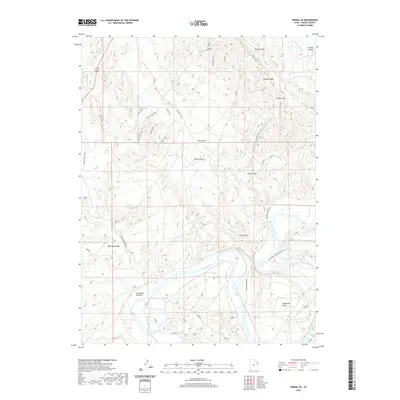
2020 Map of Vernal SE
USGS Topo · Published 2020About this map
The Green River carves a dramatic path through this Uintah County landscape, creating the prominent Horseshoe Bend and the low-lying Hamacker Bottoms. To the north, the elevation rises sharply along Asphalt Ridge, a distinctive geological feature that overlooks the western edge of Ashley Valley. The terrain is defined by a series of dry washes and high-desert flats, including McCoy Flat and its associated McCoy Knolls, which are traversed by a network of trails like Serendipity Trail. This 2020 survey demonstrates the ongoing importance of water management in the region, visible through the Highline Canal cutting across the northeast corner. The map also traces a complex system of local roads, such as Horseshoe Bend Rd and McCoy Flat Rd, providing access to the various draws and passes that mark this part of the Uinta Basin.
Find a feature on this map
23 named features on this map. Tap any name to fly to it.
Don’t see what you’re looking for? This feature index may not catch every label — zoom into the map to look around manually.
Map Details
Editions of this 2020 Vernal SE Map
This is the sole edition of this map. No revisions or reprints were ever made.
Other maps of this area

1885 · Ashley
USGS Topo · 1:250,000

1907 · Jensen
USGS Topo · 1:125,000

1910 · Jensen
USGS Topo · 1:125,000

1917 · Vernal
USGS Topo · 1:125,000

1954 · Vernal
USGS Topo · 1:250,000

1958 · Vernal
USGS Topo · 1:250,000

1960 · Vernal
USGS Topo · 1:250,000

1964 · Vernal NE
USGS Topo · 1:24,000

1964 · Brennan Basin
USGS Topo · 1:24,000
1964 · Vernal SW
USGS Topo · 1:24,000