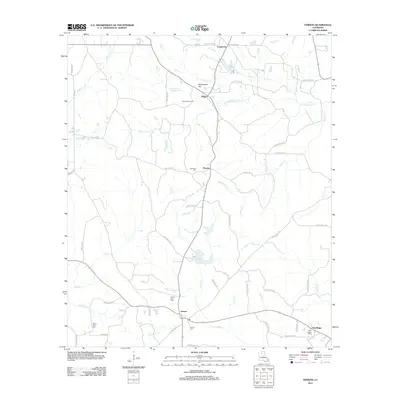
2012 Map of Vernon
USGS Topo · Published 2012About this map
Vernon and the surrounding rural communities of Jackson Parish are defined by a complex network of creeks and small gas fields in this 2012 survey. The landscape is characterized by its numerous drainage basins, including Castor Cr, Sandy Cr, and S Choudrant Cr, which dictate the placement of local roads and family-named cemeteries. Key burial sites like Vernon Cem, Ebenezer Cem, and Mount Zion Cem provide valuable touchpoints for genealogists tracking local families near the settlements of Ebenzer and Kelleys. The regional economy is anchored by natural resources, evidenced by the Kelleys Gas Field and Vernon Gas Field. Local landmarks such as Buckenham Hill rise above the many branches and creeks, while a dense grid of parish roads like Nig Dorsey Rd and Joiner Rd connects these disparate rural enclaves and small timbered tracts.
Find a feature on this map
66 named features on this map. Tap any name to fly to it.
Don’t see what you’re looking for? This feature index may not catch every label — zoom into the map to look around manually.
Map Details
Editions of this 2012 Vernon Map
This is the sole edition of this map. No revisions or reprints were ever made.
Other maps of this area

1950 · Ruston
USGS Topo · 1:62,500

1951 · Ruston
USGS Topo · 1:62,500

1952 · Calhoun
USGS Topo · 1:62,500

1953 · Chatham
USGS Topo · 1:62,500

1953 · Hodge
USGS Topo · 1:62,500

1955 · Shreveport
USGS Topo · 1:250,000

1956 · Shreveport
USGS Topo · 1:250,000

1982 · Chatham
USGS Topo · 1:24,000
1982 · Eros
USGS Topo · 1:24,000
1982 · Downsville South
USGS Topo · 1:24,000