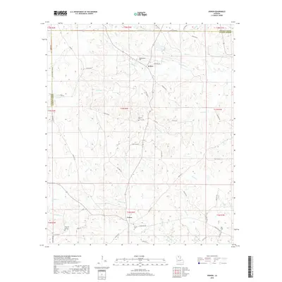
2018 Map of Vernon
USGS Topo · Published 2018About this map
The settlement of Vernon serves as a central point in this North Louisiana landscape, where the boundary between Lincoln Parish and Jackson Parish runs through a complex network of creeks and ridges. The topography is defined by significant watercourses like S Choudrant Cr and Castor Cr, which carve through the terrain near Buckenham Hill. This area is characterized by a high density of small rural cemeteries, including the Mount Zion Saint Rest Cem and Ebenezer Cem, which provide essential points of reference for genealogists tracking local family histories.
Find a feature on this map
66 named features on this map. Tap any name to fly to it.
Don’t see what you’re looking for? This feature index may not catch every label — zoom into the map to look around manually.
Map Details
Editions of this 2018 Vernon Map
This is the sole edition of this map. No revisions or reprints were ever made.
Other maps of this area

1950 · Ruston
USGS Topo · 1:62,500

1951 · Ruston
USGS Topo · 1:62,500

1952 · Calhoun
USGS Topo · 1:62,500

1953 · Chatham
USGS Topo · 1:62,500

1953 · Hodge
USGS Topo · 1:62,500

1955 · Shreveport
USGS Topo · 1:250,000

1956 · Shreveport
USGS Topo · 1:250,000

1982 · Chatham
USGS Topo · 1:24,000
1982 · Eros
USGS Topo · 1:24,000
1982 · Downsville South
USGS Topo · 1:24,000