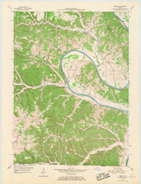
1954 Map of Vernon
USGS Topo · Published 1969About this map
The Cumberland River carves a dramatic, winding path through this region of southern Kentucky and northern Tennessee during the mid-1950s. At the heart of the landscape lies Turkey Neck Bend, a massive river loop that dominates the central terrain. Transportation at the water’s edge is anchored by McMillans Ferry, while the surrounding ridges are dotted with rural community centers. Small settlements like Vernon, Meshack, and Center Point serve as anchors for a network of country schools, including Antioch Sch and Sulphur Ridge Sch.
Find a feature on this map
53 named features on this map. Tap any name to fly to it.
Don’t see what you’re looking for? This feature index may not catch every label — zoom into the map to look around manually.
Map Details
Editions of this 1954 Vernon Map
2 editions found
Other maps of this area

1924 · Lillydale
USGS Topo · 1:62,500

1926 · Lillydale
USGS Topo · 1:62,500

1929 · Lillydale
USGS Topo · 1:62,500

1929 · Tompkinsville
USGS Topo · 1:62,500

1953 · Sulphur Lick
USGS Topo · 1:24,000

1953 · Waterview
USGS Topo · 1:24,000

1953 · Dubre
USGS Topo · 1:24,000

1954 · Blacks Ferry
USGS Topo · 1:24,000

1954 · Tompkinsville
USGS Topo · 1:24,000
1954 · Vernon
USGS Topo · 1:24,000