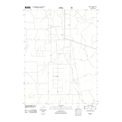
2011 Map of Vernon
USGS Topo · Published 2011About this map
Vernon stands as a focal point for this agrarian landscape in Tooele County, anchored by a grid of local roads and the Vernon Cemetery. The mapping reveals a transition between concentrated settlement and the managed grazing lands of the Benmore Experimental Pastures to the south. This area is defined by its drainage systems, where Vernon Creek, Bennion Creek, and Dutch Creek flow through the valley floor. Transportation infrastructure is represented by the Vernon Airstrip and a network of arterial routes like Vernon Rd and Douglas Rd. Local history is embedded in the family-named corridors such as Frederickson Ln and Yates Rd, while the southern reaches near Benmore show a shift toward more specialized agricultural and forest service land use. The presence of the Old Aqueduct Rd hints at the region's managed water resources in this high desert environment.
Find a feature on this map
30 named features on this map. Tap any name to fly to it.
Don’t see what you’re looking for? This feature index may not catch every label — zoom into the map to look around manually.
Map Details
Editions of this 2011 Vernon Map
This is the sole edition of this map. No revisions or reprints were ever made.
Other maps of this area

1885 · Sevier Desert
USGS Topo · 1:250,000

1885 · Tooele Valley
USGS Topo · 1:250,000

1953 · Tooele
USGS Topo · 1:250,000

1953 · Delta
USGS Topo · 1:250,000

1955 · Tooele
USGS Topo · 1:250,000

1958 · Delta
USGS Topo · 1:250,000

1962 · Delta
USGS Topo · 1:250,000
1963 · Sabie Mountain
USGS Topo · 1:24,000

1963 · Dutch Peak
USGS Topo · 1:24,000
1971 · Vernon NE
USGS Topo · 1:24,000