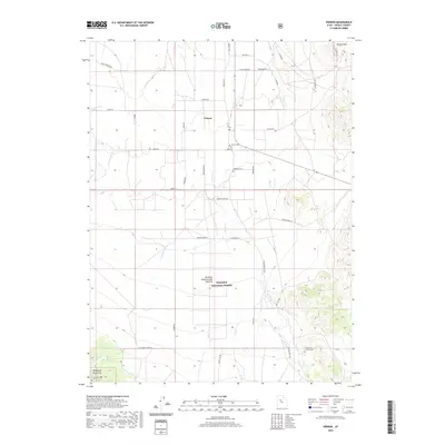
2020 Map of Vernon
USGS Topo · Published 2020About this map
Vernon serves as the central hub of this high-desert landscape in Tooele County, where agricultural life is shaped by the drainage of the Sheeprock Mountains. The town's historic footprint is anchored by the Vernon Cem and a grid of residential streets including Main St, giving way to a network of rural routes named for local families such as Harker Rd and Fredrickson Ln. South of the settlement, the Benmore Experimental Pastures occupy a significant portion of the Wasatch National Forest, illustrating the region's long-standing connection to livestock research and range management.
Find a feature on this map
46 named features on this map. Tap any name to fly to it.
Don’t see what you’re looking for? This feature index may not catch every label — zoom into the map to look around manually.
Map Details
Editions of this 2020 Vernon Map
This is the sole edition of this map. No revisions or reprints were ever made.
Other maps of this area

1885 · Sevier Desert
USGS Topo · 1:250,000

1885 · Tooele Valley
USGS Topo · 1:250,000

1953 · Tooele
USGS Topo · 1:250,000

1953 · Delta
USGS Topo · 1:250,000

1955 · Tooele
USGS Topo · 1:250,000

1958 · Delta
USGS Topo · 1:250,000

1962 · Delta
USGS Topo · 1:250,000
1963 · Sabie Mountain
USGS Topo · 1:24,000

1963 · Dutch Peak
USGS Topo · 1:24,000
1971 · Vernon NE
USGS Topo · 1:24,000