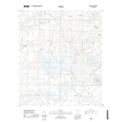
2018 Map of Vernon
USGS Topo · Published 2018About this map
Vernon and the adjacent settlement of Sylvania occupy the northern reaches of this Washington County landscape, where the terrain transitions from the elevations of Weaver Hill and Hudson Hill into the low-lying wetlands of Holmes Valley. This 2018 survey reveals an intricate network of aquatic features, including the meandering path of Holmes Creek and numerous isolated water bodies like Tea Pond and Baptizing Pond. The map serves as a vital resource for local history, documenting several rural burial sites such as Potter Cem, Tiller Cem, and Greenhead Cem. The prevalence of named bays and swamps, including Hays Maltsby Bay and Pippin Mill Swamp, highlights the persistent hydrologic character of the Florida Panhandle. The placement of Pippin Mill Cr suggests a legacy of early water-powered industry that once shaped these local communities.
Find a feature on this map
122 named features on this map. Tap any name to fly to it.
Don’t see what you’re looking for? This feature index may not catch every label — zoom into the map to look around manually.
Map Details
Editions of this 2018 Vernon Map
This is the sole edition of this map. No revisions or reprints were ever made.
Other maps of this area

1944 · Crystal Lake
USGS Topo · 1:24,000

1944 · Bennett
USGS Topo · 1:24,000

1945 · Bennett
USGS Topo · 1:31,680

1945 · Red Head
USGS Topo · 1:31,680

1945 · Crystal Lake
USGS Topo · 1:31,680

1949 · Millers Ferry
USGS Topo · 1:24,000

1949 · Hinsons Cross Roads
USGS Topo · 1:24,000

1950 · Millers Ferry
USGS Topo · 1:24,000

1950 · Hinsons Cross Roads
USGS Topo · 1:24,000

1950 · Vernon
USGS Topo · 1:24,000