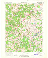
1969 Map of Verona
USGS Topo · Published 1971About this map
The Louisville & Nashville Rr cuts diagonally through this Northern Kentucky landscape, connecting the rural communities of Verona and Zion Station during the late 1960s. Located at the intersection of Boone, Gallatin, and Grant counties, the terrain is defined by the winding paths of Mud Lick Creek and the Big South Fork. The map documents a predominantly agrarian economy, evidenced by the numerous family-named roads like Ryle Road and Bishop Road, alongside localized centers of social life such as Beaverlick Sch and several country churches. A significant topographical feature is Bullock Pen Lake, which shapes the southeastern portion of the quadrangle. For genealogists, the inclusion of the St Patricks Cem and Chapman Cem provides precise locations for ancestral research in this tri-county border region.
Find a feature on this map
37 named features on this map. Tap any name to fly to it.
Don’t see what you’re looking for? This feature index may not catch every label — zoom into the map to look around manually.
Map Details
Editions of this 1969 Verona Map
This is the sole edition of this map. No revisions or reprints were ever made.
Other maps of this area

1943 · Rising Sun
USGS Topo · 1:24,000

1943 · Patriot
USGS Topo · 1:24,000

1950 · Glencoe
USGS Topo · 1:24,000

1950 · Elliston
USGS Topo · 1:24,000

1950 · Union
USGS Topo · 1:24,000

1950 · Williamstown
USGS Topo · 1:24,000

1950 · Independence
USGS Topo · 1:24,000

1950 · Verona
USGS Topo · 1:24,000

1950 · Walton
USGS Topo · 1:24,000

1951 · Rising Sun
USGS Topo · 1:24,000