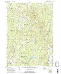
1981 Map of Vershire
USGS Topo · Published 1991About this map
Vershire and the surrounding townships of Strafford and Thetford define this upland landscape in the early 1980s. The settlement pattern follows the valley of the Ompompanoosuc River, where centers like Mill Village and West Fairlee are situated. Educational landmarks including the Vershire Sch and the Mountain Sch serve these rural communities, while the presence of Post Mills Airport in the southeast corner indicates a mix of traditional agriculture and modern aviation.
Find a feature on this map
50 named features on this map. Tap any name to fly to it.
Don’t see what you’re looking for? This feature index may not catch every label — zoom into the map to look around manually.
Map Details
Editions of this 1981 Vershire Map
4 editions found
Other maps of this area

1896 · Strafford
USGS Topo · 1:62,500

1931 · Mt. Cube
USGS Topo · 1:62,500

1931 · Woodsville
USGS Topo · 1:48,000

1933 · Mt. Cube
USGS Topo · 1:62,500

1935 · Woodsville
USGS Topo · 1:62,500

1941 · Woodsville
USGS Topo · 1:62,500

1944 · Strafford
USGS Topo · 1:62,500

1947 · Corinth
USGS Topo · 1:62,500

1948 · East Barre
USGS Topo · 1:62,500

1950 · Glens Falls
USGS Topo · 1:250,000