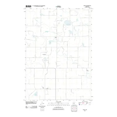
2010 Map of Veseli
USGS Topo · Published 2010About this map
Veseli anchors the southern portion of this landscape, a small community set within a grid of country roads and agricultural parcels. The terrain is defined by a dense network of small lakes and glacial depressions, including Lennon Lake and Bradshaw Lake, which feed the wandering path of Porter Creek as it flows southeast. The map reveals the persistence of early rural institutions, most notably the Saint Johns Cemetery, which appears twice as a focal point for local families and genealogists tracking area residents. Water management and conservation efforts are evident through features like the Dvorak Wildlife Pond Dam, illustrating the late-20th-century transition toward managed natural areas. From the residential developments along Wyndcrest Dr to the scattered farms connected by Panama Ave and Newport Ave, the map provides a precise view of this Minnesota countryside at the end of the 2000s.
Find a feature on this map
51 named features on this map. Tap any name to fly to it.
Don’t see what you’re looking for? This feature index may not catch every label — zoom into the map to look around manually.
Map Details
Editions of this 2010 Veseli Map
This is the sole edition of this map. No revisions or reprints were ever made.
Other maps of this area

1953 · Saint Paul
USGS Topo · 1:250,000

1957 · Prior Lake
USGS Topo · 1:62,500

1957 · New Prague
USGS Topo · 1:62,500

1959 · Saint Paul
USGS Topo · 1:250,000

1960 · Lonsdale
USGS Topo · 1:24,000

1960 · Little Chicago
USGS Topo · 1:24,000

1966 · Montgomery
USGS Topo · 1:24,000
1974 · Prior Lake
USGS Topo · 1:24,000
1974 · New Market
USGS Topo · 1:24,000
1974 · Veseli
USGS Topo · 1:24,000