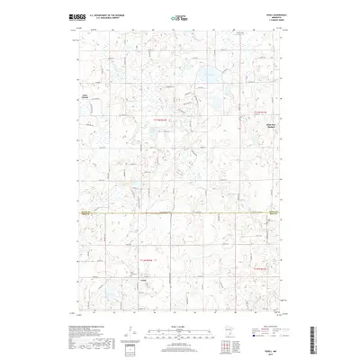
2019 Map of Veseli
USGS Topo · Published 2019About this map
Veseli and the burgeoning community of Elko New Market anchor this 2019 survey of the landscape straddling the Scott and Rice County line. The map captures a transition between traditional agrarian tracts and residential expansion, particularly evident near the northern reaches around Saint Patrick. Water defines the geography, with numerous glacial depressions forming prominent basins like Lennon Lake, Bradshaw Lake, and Hatch Lake. Local drainage is managed by systems such as Porter Cr, which winds through the northwestern sections. Genealogists will find the location of Saint Johns Cem particularly valuable for tracing local family histories in this rural corridor. The intricate grid of county roads, including Co Hwy 23 and Co Hwy 27, illustrates the modern connectivity of these historic settlements within the t113n r22w and surrounding survey townships.
Find a feature on this map
74 named features on this map. Tap any name to fly to it.
Don’t see what you’re looking for? This feature index may not catch every label — zoom into the map to look around manually.
Map Details
Editions of this 2019 Veseli Map
This is the sole edition of this map. No revisions or reprints were ever made.
Other maps of this area

1953 · Saint Paul
USGS Topo · 1:250,000

1957 · Prior Lake
USGS Topo · 1:62,500

1957 · New Prague
USGS Topo · 1:62,500

1959 · Saint Paul
USGS Topo · 1:250,000

1960 · Lonsdale
USGS Topo · 1:24,000

1960 · Little Chicago
USGS Topo · 1:24,000

1966 · Montgomery
USGS Topo · 1:24,000
1974 · Prior Lake
USGS Topo · 1:24,000
1974 · New Market
USGS Topo · 1:24,000
1974 · Veseli
USGS Topo · 1:24,000