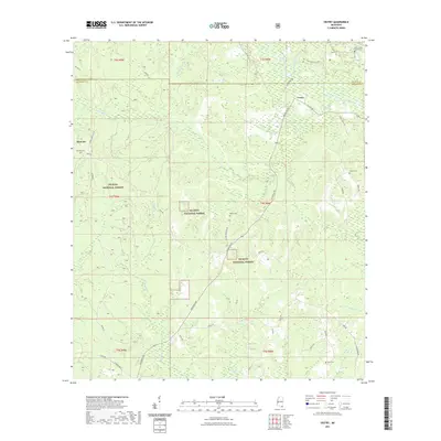
2021 Map of Vestry
USGS Topo · Published 2021About this map
De Soto National Forest covers the majority of this Jackson and George County landscape, where the small community of Vestry is situated along the rural corridor of Vestry Rd. This 2021 survey illustrates a region defined by its hydrography, with Red Creek and its numerous tributaries like Little Red Cr and Indian Camp Br threading through the timberland. To the west, the settlement of Dantzler sits near the crossing of Wire Rd and Larue Dantzler Rd. Genealogists and local historians will find several family and community burial sites scattered throughout the piney woods, including Ramsey Cem, Wilson Cem, and the Louis Flurry Family Cem near the northern boundary. The presence of the Mill Creek Hunting Club and numerous small access roads like Old Biloxi Rd and School House Rd reflects the area's contemporary use for recreation and forestry.
Find a feature on this map
44 named features on this map. Tap any name to fly to it.
Don’t see what you’re looking for? This feature index may not catch every label — zoom into the map to look around manually.
Map Details
Editions of this 2021 Vestry Map
This is the sole edition of this map. No revisions or reprints were ever made.
Other maps of this area

1941 · Vancleave
USGS Topo · 1:62,500

1941 · Lucedale
USGS Topo · 1:62,500

1943 · Lucedale
USGS Topo · 1:62,500

1943 · Vancleave
USGS Topo · 1:62,500

1944 · Vancleave
USGS Topo · 1:62,500

1947 · Benndale
USGS Topo · 1:62,500

1949 · Benndale
USGS Topo · 1:62,500

1953 · Mobile
USGS Topo · 1:250,000

1954 · Vestry
USGS Topo · 1:62,500

1957 · Mobile
USGS Topo · 1:250,000