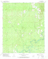
1971 Map of Vick
USGS Topo · Published 1973About this map
The Saline River defines the southern boundary of this landscape, winding through a complex network of wetlands and backwaters including Black Lake, Mud Lake, and Robinson Bay. This riverine environment supported local industry and transport, evidenced by the presence of Pine Island Landing and the river-adjacent settlement at Stillions. Higher ground to the north is characterized by a mix of small rural communities and timber-related landmarks. The Chicago Rock Island and Pacific railroad cuts diagonally across the territory, serving as a primary transit artery for the town of Vick. Local spiritual and social centers are clearly marked, including Antioch Ch, Hampton Chapel, and Calvary Ch near Johnsville. The landscape's economic character is further shaped by the numerous Gravel Pits and the timber resources reflected in Georgia Pacific Lake.
Find a feature on this map
33 named features on this map. Tap any name to fly to it.
Don’t see what you’re looking for? This feature index may not catch every label — zoom into the map to look around manually.
Map Details
Editions of this 1971 Vick Map
3 editions found
Other maps of this area

1934 · Ingalls
USGS Topo · 1:48,000

1934 · Felsenthal
USGS Topo · 1:62,500

1937 · Felsenthal
USGS Topo · 1:62,500

1937 · Ingalls
USGS Topo · 1:62,500

1938 · Felsenthal
USGS Topo · 1:62,500

1939 · Felsenthal
USGS Topo · 1:62,500

1939 · Ingalls
USGS Topo · 1:62,500

1953 · Greenwood
USGS Topo · 1:250,000

1953 · El Dorado
USGS Topo · 1:250,000

1956 · Greenwood
USGS Topo · 1:250,000