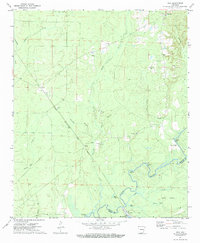
1971 Map of Vick
USGS Topo · Published 1984About this map
Saline River bottomlands and the timbered uplands of Bradley County define this early 1970s landscape. The Chicago Rock Island and Pacific railroad cuts through the terrain, serving the small community of Vick, while an Old R R Grade to the north hints at earlier logging or transit routes. The presence of Moores Mill and various Gravel Pits reflects the local economy's reliance on the land's natural resources. Rural life is anchored by local congregations at Antioch Ch, Hampton Chapel, and Calvary Ch. Down by the river, the map documents a series of water features including Robinson Bay, Black Lake, and the landing at Stillions. These details provide a clear picture of the Arkansas timber belt before more modern industrial shifts, showing the tight connection between the river, the rail, and the small settlements of Johnsville and Vick.
Find a feature on this map
33 named features on this map. Tap any name to fly to it.
Don’t see what you’re looking for? This feature index may not catch every label — zoom into the map to look around manually.
Map Details
Editions of this 1971 Vick Map
3 editions found
Other maps of this area

1934 · Ingalls
USGS Topo · 1:48,000

1934 · Felsenthal
USGS Topo · 1:62,500

1937 · Felsenthal
USGS Topo · 1:62,500

1937 · Ingalls
USGS Topo · 1:62,500

1938 · Felsenthal
USGS Topo · 1:62,500

1939 · Felsenthal
USGS Topo · 1:62,500

1939 · Ingalls
USGS Topo · 1:62,500

1953 · Greenwood
USGS Topo · 1:250,000

1953 · El Dorado
USGS Topo · 1:250,000

1956 · Greenwood
USGS Topo · 1:250,000