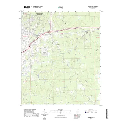
2018 Map of Vicksburg East
USGS Topo · Published 2018About this map
Vicksburg National Military Park dominates the northern reaches of this landscape, preserving the complex topography of the 1863 siege lines. The city of Vicksburg extends eastward from the river bluffs, transitioning into the suburban and rural communities of Beechwood and Newmans Grove. This era of development is defined by the heavy infrastructure of the Kansas City Southern railroad and a dense network of residential streets that weave around historical landmarks like Ft Hill. Significant for genealogists, the map identifies several distinct burial grounds, including Beulah Cem, Anshei Chesed Cem, and Tates Cem. The hydrology is shaped by numerous drainages such as Hatcher Bayou, Stouts Bayou, and Durden Cr, which carved the deep ravines that dictated the military and civil engineering of the region.
Find a feature on this map
180 named features on this map. Tap any name to fly to it.
Don’t see what you’re looking for? This feature index may not catch every label — zoom into the map to look around manually.
Map Details
Editions of this 2018 Vicksburg East Map
This is the sole edition of this map. No revisions or reprints were ever made.
Other maps of this area

1918 · Vicksburg
USGS Topo · 1:62,500

1938 · Edwards
USGS Topo · 1:62,500

1939 · Yokena
USGS Topo · 1:62,500

1941 · Vicksburg
USGS Topo · 1:62,500

1955 · Jackson
USGS Topo · 1:250,000

1961 · Jackson
USGS Topo · 1:250,000

1962 · Jackson
USGS Topo · 1:250,000

1962 · Redwood
USGS Topo · 1:24,000

1962 · Vicksburg West
USGS Topo · 1:24,000
1962 · Long Lake
USGS Topo · 1:24,000