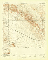
1918 Map of Victorio
USGS Topo · Published 1946About this map
The United States-Mexico international border defines the southern edge of this 1918 survey, where the rugged terrain of the Cedar Mountain Range dominates the landscape of southern New Mexico. Mining and ranching appear as the primary drivers of settlement and activity during this era. The Sierra Rica Mines and Occidental Mines are situated along the southern boundary, suggesting the region's mineral importance. Transport across this arid environment relied heavily on the El Paso and Southwestern railroad, which passes through Victorio and Savoya.
Find a feature on this map
23 named features on this map. Tap any name to fly to it.
Don’t see what you’re looking for? This feature index may not catch every label — zoom into the map to look around manually.
Map Details
Editions of this 1918 Victorio Map
Other maps of this area

1899 · Deming
USGS Topo · 1:125,000

1915 · Deming
USGS Topo · 1:125,000

1917 · Hermanas
USGS Topo · 1:62,500

1918 · Big Hatchet Peak
USGS Topo · 1:62,500

1918 · Hachita
USGS Topo · 1:62,500

1918 · Hermanas
USGS Topo · 1:62,500

1918 · Victorio
USGS Topo · 1:62,500

1943 · Hermanas
USGS Topo · 1:62,500

1953 · El Paso
USGS Topo · 1:250,000

1954 · Silver City
USGS Topo · 1:250,000